- Profile Jurisdictions GOV DEPARTMENTS Cultures Travelling Educate
-
Geographical Location
Nayong County is located between 104°55'40‘ and 105°38'4’ east longitude, and 26°30'16‘ and 27°5'54’ north latitude. It is situated in the northwestern part of Guizhou Province and the southeastern part of Bijie Region, resembling a goat lying on its side with its head facing west and tail facing east, nestled between the southeastern foothills of the Wumeng Mountain Range and the Liu Chong River and Sancha River. To the southeast, it borders Zhenjin and Liuzhi; to the southwest, Shuicheng; to the northwest, Bijie and Hezhang; and to the northeast, Dafang.
Area
The county spans 56 kilometres from east to west and 48 kilometres from north to south, with a total area of 2,448 square kilometres.
Population
At the end of the year, the county had a registered population of 1,096,200, including 480,100 urban residents and 616,100 rural residents. There were 575,200 males and 521,000 females. The county's permanent resident population at the end of the year was 693,000.
Administrative History
During the Shang and Zhou dynasties, the present-day Nanyong area belonged to the Gui Fang region. During the Spring and Autumn Period, it was part of the Zangke ancient kingdom. At the beginning of the Warring States Period, the Zangke ancient kingdom declined and fragmented, and the Yelang kingdom emerged. Most of Guizhou was under the jurisdiction of the Yelang kingdom, and the present-day Nanyong area was also within its borders. In the 26th year of Emperor Qin Shi Huang's reign (221 BCE), the Yelang region was annexed, and counties such as Yelang and Hanyang were established. Today's Nayong belonged to Hanyang County, which was part of Xiang Commandery.
In the 6th year of Emperor Wu's reign (135 BCE), Jianwei Commandery and counties such as Ying, Hanyang, Pingyi, Zhuti, and Yuyan were established. Today's Nayong belonged to Pingyi County. In the sixth year of Emperor Wu's reign (111 BCE), the Zangke Commandery was established, and Pingyi was transferred to Zangke. In the fourth year of Emperor Guangwu's reign (4 CE), Zangke was renamed Tongting; in the first year of Emperor Tai'an's reign (302 CE), the Ningzhou Commandery was established, with Zangke and Zhuti under its jurisdiction. In the fifth year of Yongjia (311), Zangke was divided into Zangke, Pingyi, and Yelang commanderies. Later, to avoid the taboo name of Huan Wen, Pingyi Commandery was renamed Pingman Commandery, and Pingyi County became Pingman County. Today, Nayong was originally part of Pingyi County under Pingyi Commandery and later became part of Pingman County under Pingman Commandery.
During the Southern and Northern Dynasties, in the Taiqing era of the Liang Dynasty, Ningzhou was occupied by the Cuan clan (historically known as the Wuman), and all counties and prefectures were abolished. In the third year of the Longshuo era of the Tang Dynasty (663), Xie Facheng, the governor of Ju Prefecture, recruited and pacified Bilou and others, totaling 7,000 people, who submitted to the Tang Dynasty. In the third year of the Zongzhang era (670), Lu Prefecture and Tangwang Prefecture were established in the territory of Bilou. During the Tang Dynasty, part of present-day Nayong belonged to Tangwang Prefecture and Hao Prefecture, which were respectively under the jurisdiction of the Qiang Prefecture Military Governor's Office and the Shu Prefecture Military Governor's Office. However, ‘they were all tributary states.’
During the Five Dynasties period, the administrative divisions were retained. By the end of the Song Dynasty, all the states were abolished, and the region was referred to as the Luo Clan Ghost Kingdom, encompassing the original Hao, Yi, Gong, Jian, Hui, Lu, Tangwang, and Zhangge counties, as well as the original Zhangge Prefecture. The present-day Nanyong area was part of its territory.
In the 15th year of the Zhi Yuan era of the Yuan Dynasty (1278), the Luo clan's ruler, A Zuo, submitted to the Yuan Dynasty. An imperial edict appointed him as the regional governor of the area, and the Wusha Military and Civilian General Administration was established. In the 19th year (1282), the Shun Yuan Military and Civilian Commissioner's Office and the Grand Marshal's Office were established, along with the Yixi Buxue, A Qie, and A Long three regional Darughachi offices. In the 20th year (1283), the Yixibuxue Military and Civil Affairs Office and the three regional native officials were established. Later, the three regions were merged into one, and the Yixibuxue Military and Civil Affairs Office was established, with Ali as the commander. In the 7th year of the Dade era (1303), the Yixibuxue Military and Civil Affairs Office and the Military and Civil Affairs Office were abolished, and the eight regions of Shunyan were merged. The Shun Yuan Xuanfu Office was relocated to Yixi Buxue, with A Hua appointed as Xuanfu Shi (Governor) stationed in Shuixi, and A Zhong as Deputy Governor stationed in Shuidong. The Xuanfu Office was downgraded to a Xuanwei Office, overseeing 24 indigenous chiefdoms, with eight in Shuixi. Today, Nayong is part of the territories under the jurisdiction of the Muwo, Pude, Puzhong, and Shibei Dong chiefdoms.
In the fifth year of the Hongwu era of the Ming Dynasty (1372), Shun Yuan was renamed Guizhou, and the Guizhou Xuanwei Office was established. In the third year of the Chongzhen era (1630), the Guizhou Xuanwei Office was renamed the Shuixi Xuanwei Office, but it only governed the Shuixi region, which was divided into Zhongshui, Xiashui, and Dishui. This system retained the old structure of the three Darughachi and three tribal chieftains, with each region overseeing four clan chiefs, later mispronounced as Zexi. Each clan chief had four local officials under them, totaling 48 officials. At that time, the local officials such as Gui Zong, Shao Zuo, Zong Ji, Yi Zhi, and Yi Ge were all located in present-day Nayong. Approximately, the townships of Zongling, Yangchang, Lezhi, and Juren in present-day Nayong belonged to Huozhe Zexi, while Weixin, Gukai, Longchang, and Zhikun belonged to Mukuo Zexi, and Zhangwei and part of Yongxi belonged to Fago Zexi.
In the fourth year of the Kangxi reign (1665), the four prefectures of Dading, Pingyuan, Qianxi, and Weining were established using the territory of Shuixi. The Dading Prefecture was formed by compiling the original Huozhe Zexi territory into the two townships of Yuefu and Leigong, the original Huozhe Zexi territory into the two townships of Dayou and Jiahe, the original Jiale Zexi territory into the two townships of Yongshun and Changping, and the original Mukuo Zexi territory into the two townships of Renyu and Yijian. Yuefu Township included the present-day townships of Nayong Zailuo, Longchang, Zhikun, and part of Weixin. Dàyǒu Township included the townships of Lezhi, Lao'ao Ba, Shabao, Wangjia Zhai, Shuidong, and part of Yongxi Town. Jiāhé Township included the townships of Zongling, Yangchang, Baoxing, Shuguang, and part of Yongxi Town. Renyu Li includes most of Weixin and Gukai. Pingyuan Prefecture's Yuren Li includes Zhangwei and part of Baoxing. In the 22nd year (1683), Qianxi and Pingyuan were renamed as prefectures and placed under the jurisdiction of Dading Prefecture. At the same time, the Shuixi Xuanwei Office and the Awu Chieftain's Office were re-established. In the 26th year (1687), Dading Prefecture was renamed as a prefecture and placed under the jurisdiction of Weining Prefecture along with Qianxi and Pingyuan. In the 37th year (1698), the Shuixi Xuanwei Office and the Awu Chieftain's Office were abolished. In the eighth year of the Yongzheng reign (1730), Dading was restored as a prefecture, and Weining was restored as a prefecture, both subordinate to Dading along with Qianxi, Pingyuan, and Bijie. Today, Nayong is directly administered by Dading Prefecture. In the 11th year (1733), Shuicheng Hall was established, with the prefecture administering Yongshun and Changping Li under its jurisdiction (later, Chongxin, Shifeng, and Suiren Li of Pingyuan Prefecture were also transferred). Today, parts of Nanyong's Zhuchang and Xinfang Townships (formerly part of Yongshun Li) were also transferred from Dading Prefecture's directly administered territory to Shuicheng Hall's jurisdiction.
In the 3rd year of the Republic of China (1914), the prefecture was abolished and replaced with a county, with Dading Prefecture renamed Dading County. The former directly administered territories of Dading Prefecture were divided into nine districts. Most of present-day Nayong belongs to the First, Second, and Third Western Districts. The First Western District Office is located in Dading Dui Jiang Village, overseeing present-day Nayong Lezhi, Lao'ao Dam, Shabao townships, and part of Wangjia Zhai Town; The West Second District Office was located in Datuochang, overseeing the present-day townships of Yongxi, Zongling, Yangchang, and Baoxing, as well as part of Wangjiazhai Town; the West Third District Office was located in Yilie Maochang, overseeing the present-day townships of Weixin, Longchang, Gukai, and Zhikun in Nayong.
In 1924 (the 13th year of the Republic of China), Dading County was reorganised into 11 districts, with most of present-day Nayong County divided among West Districts 1, 2, 3, and 4. West Districts 1 and 2 remained unchanged, The seat of the West Third District Office remained unchanged, but its jurisdiction was expanded to include present-day Dongdi, Huazuo Township, and most of Longchang Town. The seat of the West Fourth District Office was moved to Xiaotuchang (present-day Weixin), and its jurisdiction included present-day Weixin, Dongguan, Gukai, Yangchang, Guoquanyan, Kunzhai, Zuojiaojia, Zailuo, and other townships, as well as most of Longchang Town and part of Zhuchang Township.
In 1928, Dading County was reorganised into 20 districts, with most of present-day Nayong belonging to Districts 4, 5, 6, and 7. The West Fourth District Office was located in Dalongchang (now Longchang Town), overseeing the present-day towns of Longchang, Zhaoluo, and Dongdi; The West Fifth District Office was located in Datuochang, overseeing the present-day towns of Yongxi, Wangjia Zhai, Lezhi, Shabao, Shaowo, and part of Zhangjiawan Town; The West Sixth District Office was located in Bainituan (now Baixing), overseeing the towns of Yangchang, Zongling, Shuguang, and most of Baixing Town; the West Seventh District Office was located in Xiaotuchang, overseeing the towns of Weixin, Shidongguan, Dongdi, Huazuo, Kunzhai, Zuojiaojia, Guka, Yangchang, Guoquanyan, and part of Zhuchang.
In 1931, Dading County was reorganised into 10 main districts and 10 sub-districts, with most of Nayong belonging to Districts 6, 7, and 8 and their sub-districts. The District 6 Office was located in Datuochang, administering the former territory of District 5, while the sub-district of Bainituan administered the former territory of District 6; The Seventh District Office was located in Xiaotuchang, overseeing Weixin, Shidongguan, Huazuo, and Dongdi, while the sub-district office was located in Guoquanyan Ma Chang, overseeing the present-day townships of Gukai, Yangchang, and Guoquanyan; The Eighth District Office was located in Dading Yilie Ma Chang, while the sub-district office was located in Dalongchang, overseeing the former territory of the Fourth District.
In 1936 (the 25th year of the Republic of China), Dading County was reorganised into nine districts, with most of Nayong County falling under Districts Five, Six, and Seven. The Fifth District Office was located at Datuochang, overseeing the townships of Lezhi, Shabao, Yongxi, Shaowo, Wangjiazhai, Yangchang, Zongling, Shuguang, and Baoxing; the Sixth District Office was located at Dading Yilie Maochang, overseeing the territory of the original Eighth District's sub-district within Nayong; the Seventh District Office was located at Xiaotuochang, overseeing the territory of the original Seventh District's main and sub-districts.
Nayong County originally belonged to Dading Prefecture (now Dafang County). In 1941, the Nayong County Establishment Preparatory Office was established. Since there is a Nayong River to the south of the county, the county was named Nayong (also taking the meaning of ‘harmonious and prosperous for the people’). On 1 July of the same year, the Nayong County Government was established.
Geological Conditions
Nayong is located at the western end of the ancient Qianzhong Uplift. The geological strata are poorly developed, with most of the Early Palaeozoic strata missing. Only the Upper Cambrian strata are exposed, while the Mesozoic Permian and Triassic strata are the most widely distributed and well-developed. The Jurassic strata are only sparsely developed in the western part.
Nayong is situated in the central part of the Yangzi Fold Belt, where folds and faults are well developed, and the orientation of tectonic lines varies significantly.
Magmatic activity primarily manifested as the eruption of Emeishan basalt and the development of associated subvolcanic rocks during the late Permian and early Triassic periods. Other magmatic activity occurred during the early Middle Triassic, late Permian, and early Triassic periods, resulting in the formation of tuffaceous conglomerates. The former had a larger scale and was closely related to mineralisation.
Topography and landforms
Nayong is located at the western end of the ancient Qianzhong Uplift, forming part of the Qianxi Plateau, the second tier of the Guizhou Plateau, which serves as the transitional zone between the Yungui Plateau and the Qianzhong Plateau. The terrain slopes from northwest to southeast, with higher elevations in the northwest and lower elevations in the northeast and southwest. The mountain ranges within the region extend in an ‘L’ shape from northwest to southeast. The southeastern branch of the Hezhang Jiuciping Mountain Ridge, the highest elevation in the province, enters from the northwest, passes through the Laigebao Mountains and connects with the Shiren Daliangzi and Kunzhai Liangzi ridges, extending towards the central and southwestern regions. It connects with the Maziling, Doupengqing, Shuozuo Daxue, and Jiebanqing Daxue, spanning the southeast and sloping toward the northeast and southwest wings in a ridge-like pattern. East of the northeastern line of Longchang, there is a series of northeast-trending, multi-character-shaped folds and faults, including the Gouhexi Syncline, Lezhi Syncline, and Luzui Syncline, which belong to the Huaxia tectonic system. West of the northeastern line of Longchang, there are northeast-trending parallel folds and faults, including the Baogu Shan anticline, Yinchang Gou anticline, Shao Zuo anticline, and Dou Peng Qing anticline, which belong to the Huaxia-type structure. The highest peak in Nayong County is Laigebao Mountain in the northwestern part, with an elevation of 2,476.40 metres. The lowest point is Lezhi Huangmaozhai Chahekou in the eastern part, with an elevation of 1,052 metres. The average elevation is 1,684 metres, with a relative elevation difference of 1,424 metres. Within Nayong County's total area of 2,448 square kilometres, mountainous terrain with a relative elevation difference exceeding 400 metres covers 534.97 square kilometres, accounting for 21.09% of the total area; medium-sized mountainous terrain with a relative elevation difference between 300 and 400 metres covers 767.81 square kilometres, accounting for 31.40%; There are 534.17 square kilometres of small mountainous areas with a relative elevation difference of 200–300 metres, accounting for 21.80%; among these, 609.55 square kilometres are small hills and valleys, accounting for 24.90%.
The land is mostly sloping with steep gradients. Among the total area, flat areas with a slope of less than 5 degrees cover only 247.20 square kilometres, accounting for 10.10%; gently sloping areas with a gradient of 5–15 degrees cover 386.80 square kilometres, accounting for 15.80%; 1,047.80 square kilometres of moderately sloped areas with a gradient of 15 to 25 degrees, accounting for 42.80%; 501.80 square kilometres of steeply sloped areas with a gradient of 25 to 35 degrees, accounting for 20.50% of the total area; and 264.40 square kilometres of extremely steeply sloped areas with a gradient exceeding 35 degrees, accounting for 10.80% of the total area.
Due to mountainous terrain, rivers flow east-west along the terrain, forming two major river systems: the Zongxi River-Guazhong River system, flowing west to northeast, with a basin area of 1,739 square kilometres; and the Nayong River system, flowing northwest to southeast, with a basin area of 680.60 square kilometres. The erosion of water flows has severely damaged the plateau surface, resulting in plateau mountains, slopes, and river valley depressions.
The topography within Nayong County includes five types: high mountains, medium mountains, low mountains, depressions, and basins.
Climate Characteristics
The county has a mild climate, with no severe cold in winter or extreme heat in summer. The annual average temperature is 14.8°C, with an average of 1,439.2 hours of sunshine per year, an annual average rainfall of 1,226 millimetres, 217 rainy days per year, and a frost-free period of 250 days. It has a subtropical monsoon climate, suitable for the growth of crops such as corn, rice, potatoes, tobacco, and citrus fruits.
Land Resources
The county currently has 95,400 hectares of arable land.
Mineral Resources
Nayong is a resource-rich county with good development prospects. Over 20 types of mineral deposits have been identified, including coal, lead-zinc, marble, pyrite, fluorite, dolomite, and limestone. Among these, the reserves of smokeless coal amount to 12.3 billion tonnes, accounting for 14.4% of the province's total reserves and ranking fourth in the province. The recoverable reserves are 6.8 billion tonnes, with high-quality coal characterised by low sulphur, low ash, and high calorific value. The geological reserves of lead-zinc are 100,000 tonnes, with high grades and ease of extraction. Marble reserves amount to 68.63 billion cubic metres, which can be mined in layers and naturally form slabs. The black marble with flat layers has been named ‘Na Mo Yu’ by experts, and there are over ten varieties such as tiger skin and water wave patterns, all of which can be processed into slabs, floor tiles, and crafts; iron ore reserves amount to 1.03 million tonnes, and pyrite reserves amount to 0.74 million tonnes. Abundant hydropower resources with a developable capacity of 60,000 kilowatts, currently only 10,000 kilowatts have been developed. Two 4×300,000-kilowatt thermal power plants have been constructed, making it an important energy base for Guizhou's ‘West-to-East Power Transmission’ initiative. A coal-to-clean fuel project with an investment of over 33 billion yuan and an annual production capacity of 2 million tonnes has been included in national planning and approved by relevant departments, with construction expected to commence soon.
Natural Resources
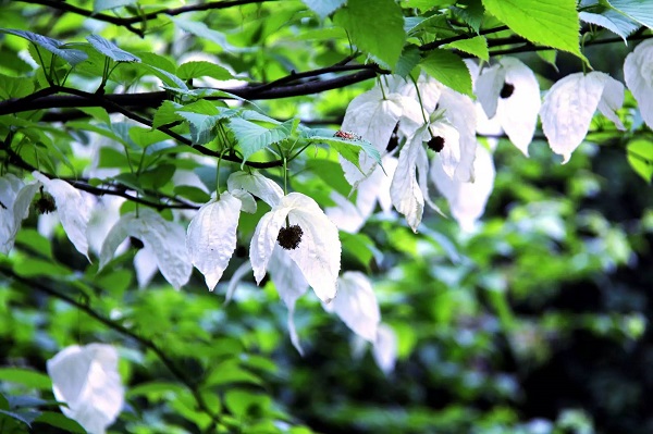
Nayong has relied on projects such as the ‘China 3356 Project,’ the Long-Term Forest Protection Project, the Natural Forest Conservation Project, the Grain-for-Green Project, and agricultural development projects to plant a large number of timber forests and economic forests. The county is rich in economic crops such as tobacco, lacquer, walnuts, tea, bamboo mushrooms, Eucommia, Phellodendron, and Tianma, and has good conditions for developing livestock farming. The county has nearly 300,000 acres of tea plantations, with excellent quality, making it the only ‘National Top Ten Ecological Tea-Producing County’ in Guizhou Province and named the ‘China High-Altitude Ecological Organic Tea Hometown.’ Nayong is rich in biological resources, with approximately 30 square kilometres of rare plants—Davidia involucrata. It is the largest and most abundant natural distribution area of Davidia involucrata in China and has been named the ‘Hometown of Davidia involucrata in China’ by the National Forestry Administration. Nayong is the birthplace of the agate red cherry and is known as the ‘Hometown of Agate Red Cherries.’
Cultural Resources
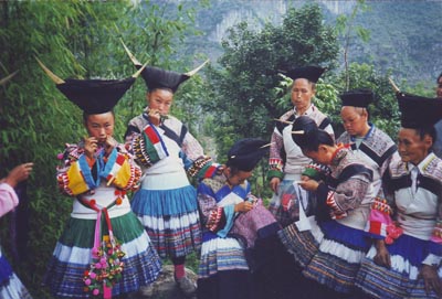
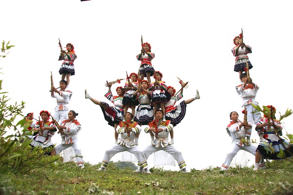
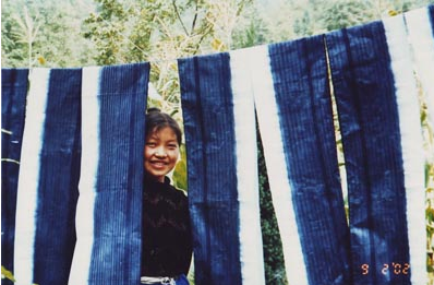
Nayong is a multi-ethnic region, with 22 minority groups including the Miao, Yi, Bai, Bouyei, Hui, Dong, and Zhuang. The ethnic customs are diverse and vibrant, including the Miao's ‘Jumping Flower Hill’ and ‘Dancing Gua,’ the Yi's ‘Caozi Dance,’ the Bouyei's ‘June Sixth Festival,’ and the Chuanqing people's ‘Dancing with In-laws,’ all brimming with strong local colour. The Miao ethnic group's ‘Rolling Mountain Pearls’ reed pipe dance and Qing Miao clothing have been designated as national-level intangible cultural heritage. The Xiaohua Miao clothing, Miao ethnic group's flying songs, ‘Splitting Chopsticks Ancestor Worship,’ Miao ethnic group's wax printing, and Nayong Nuo Opera are provincial-level intangible cultural heritage. In particular, the Miao bamboo flute dance ‘Rolling Mountain Pearls,’ with its ancient, vigorous, and astonishing dance moves, has been performed abroad multiple times and received widespread acclaim. Additionally, the Miao wax printing and embroidery are also uniquely distinctive and令人赞叹. Nayong has a thriving folk poetry culture and has been designated by the Ministry of Culture as a ‘Chinese Folk Culture and Art Homeland.’
Nayong is a region where karst topography is widely developed, with blind valleys, underground streams, and peak forests found everywhere. Major tourist attractions include the Zongxi River Scenic Area, known as the ‘Little Three Gorges,’ the majestic and spectacular Diao Shuiyan Waterfall, the fragrant azalea-lined Guoshi River Reservoir, and the bizarre and mysterious cave landscapes of Taoyuan Cave, Pengjia Cave, Xuanwei Cave, and Bailong Cave. There are also the Wan Shou Bridge, the Shaxi Palace, azalea-scented Guoshi River Reservoir, and the bizarre and mysterious cave landscapes of Taoyuan Cave, Pengjia Cave, Xuanwei Cave, and Bailong Cave. Historical sites include the Wanshou Bridge, Shaxiang Palace, the ancient battlefield of Houer Guan, and the Red Army's passage through Qiangan Rock.
National Economy
According to the unified calculation of regional gross domestic product (GDP), the county achieved a regional GDP of 20.861 billion yuan in 2024, representing a year-on-year increase of 4.6%. Among these, the added value of the primary industry was 4.551 billion yuan, up 3.3%, accounting for 21.82% of the regional GDP; the secondary industry contributed 5.917 billion yuan, up 9.0%, accounting for 28.36% of GDP; the tertiary industry contributed 10.394 billion yuan, up 2.9%, accounting for 49.82% of GDP. The per capita GDP for the year was 30,016 yuan, an increase of 5.7% over the previous year.
Agriculture and Rural Revitalisation
In 2024, we will continue to consolidate the achievements of the ‘3+1’ guarantee policy, with the employment rate of poverty-alleviated labour force reaching 94.5%, and each household of relocated residents having at least one stable employed member. A one-time transportation subsidy of 32.28 million yuan was distributed for inter-provincial migrant workers, and agricultural support measures were implemented.
contact details
Tel:00-86-0857-3521710
Address:Nayong County Yongxi Street Park Community No. 2 Middle Road
Working hours:Monday to Friday, 8:30am–12:00pm, 2:30pm–6:00pm (excluding national public holidays)