- Profile Jurisdictions GOV DEPARTMENTS Cultures Travelling Educate
-
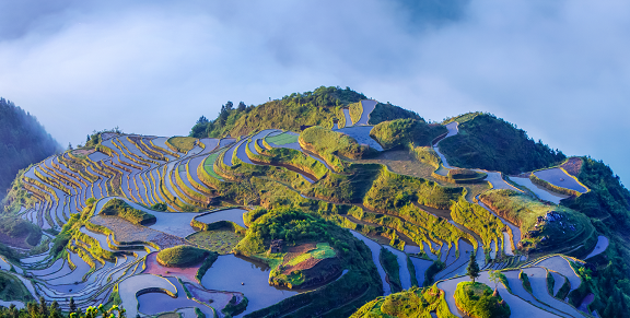
Congjiang County is located in the southeastern part of Qiandongnan Miao and Dong Autonomous Prefecture, Guizhou Province, at longitude 108°05′–109°12′ and latitude 25°16′–26°05′. To the north, it borders Rongjiang County within the same province; to the west, it connects with Libo County of Qiannan Prefecture and Huanjiang County of Guangxi Province; to the south, it reaches the border of Rongshui County in Guangxi Province; and to the east, it adjoins Liping County within the same prefecture and Sanjiang County of Guangxi Province. The county spans 94 kilometers from east to west and 77.5 kilometers from north to south, with a total area of 3,244 square kilometers. The county seat is located in Jingmei Subdistrict, situated along the Duliujiang River. The county’s climate belongs to the southern edge of the subtropical humid monsoon climate zone. Topographically, Congjiang County is part of the low mountain and hilly region on the southeastern edge of the Yungui Plateau. Its topographical features generally exhibit a trend of higher elevations in the southwest, moderately higher in the north, lower in the central area, and even lower in the east. Based on their formation, the terrain can be divided into the following regions: the northeast belongs to the low mountainous and hilly area of the southwest tail of the Xuefeng Mountain Range; the northwest belongs to the low mountainous and hilly area of the southeast end of the Miao Ling Mountain Range; the south and southwest belong to the medium mountainous area of the Jiwan Mountains, a branch of the Yuanshao Mountain Range; and the east belongs to the low mountainous and hilly area of the middle reaches of the Duliu River. The county's topography is structured around the Duliu River as a horizontal axis, with the terrain rising on either side. The gradual changes in mountainous terrain on both sides of the Duliu River form the skeletal framework of Congjiang County's topography. Mountainous areas cover 2,963 square kilometers, accounting for 91.34% of the total area, while plains cover 64 square kilometers, accounting for 2%, and river floodplains account for approximately 4%. The general relative elevation difference across the county ranges from 300 to 500 meters, with the steep southwestern region reaching a maximum elevation difference of 700 to 800 meters. The highest peak is the Yuan Tou Jie Peak of the Jiu Wan Mountains, with an elevation of 1,670 meters, while the lowest point is where the Duoliu River exits the county, at an elevation of 145 meters, resulting in a relative elevation difference of 1,535 meters. Hydrological resources: The county is located within the Pearl River Basin and the Liu River system, situated in the middle reaches of the Duliujiang River. Due to the influence of topography and terrain, the main stem of the Duliujiang River flows from north to south across the entire county. There are 87 rivers of various sizes densely distributed within the county, with a watershed area of 20 square kilometers and a river segment length of 66 kilometers within the county. The county's total hydropower potential is 278,705 kilowatts, of which: 193,270 kilowatts have been developed, accounting for 69.3% of the county's total potential; 37,450 kilowatts have been allocated, accounting for 13.4% of the county's total potential; and 45,860 kilowatts remain undeveloped, accounting for 17.3% of the county's total potential. In 2024, the county's registered population was approximately 395,000, and the permanent resident population was approximately 310,000. The county's birth rate was 2.2‰, the death rate was 5.4‰, and the natural population growth rate was 6.8‰. Among the population, ethnic minorities accounted for 95%, with the main ethnic groups being the Miao, Dong, Zhuang, Yao, and Shui minorities. Tourism Resources. Congjiang County boasts stunning natural landscapes and authentic ethnic cultures, earning it recognition from experts as one of the counties in Guizhou Province—and even nationwide—with the most numerous tourist attractions, the most comprehensive range of resource types, the strongest authenticity, and the best-preserved heritage. It is also one of the priority tourism development zones along Guizhou Province's eastern corridor. Congjiang's tourism resources possess five distinctive characteristics: authenticity, diversity, uniqueness, combinability, and scale. Currently, Congjiang County has been designated as: a pilot county for the protection of global important agricultural cultural heritage, China's Dong Grand Song Homeland, China's Folk Culture and Art Homeland, China's Fragrant Pig Homeland, China's Premium Pomelo Homeland, National Model County for Military-Civilian Unity, and Guizhou Province's Longevity Homeland. The most representative scenic spots and ethnic villages within the county include: China's Dong Grand Song Homeland—Xiaohuang Dong Village; The Last Gunman Tribe in the World — Bashi Miao Village; China's Historical and Cultural Village — Zengchong Dong Village; National Key Cultural Relic Protection Unit — Zengchong Drum Tower; China's First Village for Population and Birth Culture — Zhanli Dong Village; Agricultural Culture Museum and National Terraced Field Park — Jiabang Terraced Fields, as well as the神奇独特的Yao Ethnic Group Herbal Bath, hailed as one of the “World's Three Great Bathing Cultures.”
contact details
Tel:00-86-0855-6419000
Address:5th Floor, Building 3, North Administrative Center, Congjiang County, Qiandongnan Prefecture, Guizhou Province
Working hours:Official working hours: Morning: 8:30–12:00 Afternoon: 14:00–17:30